Our starting point is the village of Jetřichovice, located near the intersection of hiking trails that would take you to either the Bohemian Saxony National Park or to the Lužické Mountains. The charming character of this picturesque village is further enhanced by many timbered and half-timbered folk houses and by the valuable Church of St. John Nepomucký. We start at the Jetřichovice crossroad – bus station and follow the red signs to Pavlinino údolí (Pavlina's valley – public swimming pool.
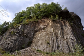
From Jetřichovice we first cross over a slightly steep hill before we find ourselves in the valley of Chřibská Kamenice. In this location, where we travel down to the valley, and near the public swimming pool and a camping site, the vast plain of Chřibská Kamenice turns into Pavlina's Valley. Our route meanders along the 3 km long rocky mine between wooded hills and sandstone cliffs. We are slowly leaving the valley and begin to climb to the village of Studený. To get to the top of Studenec from the village we have to overcome a difference in elevation of more then 400 m on a 5 km long stretch. We are now walking around the guest house Kamzík and slowly begin with a very sharp climb. Right before the top the climb eases off for a while as we go around the wooded peak and large rubble fields. To overcome the last 500 m, we have to undergo a very steep climb in order to reach the 736.5 m high peak of Studenec, where we find our second oldest metal viewing tower, built in 1888. However, in September 2007 the tower was in a desolate condition and was transported by helicopters to Lipnice, where its reconstruction took place. The repaired tower should be back in its original location before July 15, 2008, that is on the day of the 120th opening anniversary. Since 1965 the top of the mountain has belonged to the natural heritage protection zone, focusing on the protection of forests typical for the Lužické Mountains. Here we can also come across the artificially introduced chamois. We continue on a steep downhill walk for about 1 km until we reach Sedlo pod Studencem, where we may shorten our trip and follow the blue signs for 6 kilometres, all the way to the village square in Chřibská. But we continue on and follow the red signs to Křížový Buk (Beech Cross). Without any need to overcome any significant elevations we continue comfortably around a cottage settlement and a Memorial commemorating the encounter between Austrian and Prussian troops in 1757, until we reach the turn to Zlatý vrch (Golden peak).. After about 600 metres from the turn, we reach a unique basalt peak, where in the sixties of the last century an interesting structure with regular columnar difference was uncovered during regular mining activities. Mining was stopped and the uncovered top with a 30 m high olivine basalt column is now a National natural monument. Back on our route, we are "traversing" between the Javorek and Široký kopec (Wide Hill) peaks until we reach the "Beech Cross" crossroads. Beech Cross is located at the place where in 1757 most of the soldiers killed during the fierce fighting between Prussia and the Austrian army were buried. Here, we make a turn and join the green signs towards Chřibský peak. We are slowly moving down around old military bunkers and after we cross the road we begin climbing slightly until we reach the turn which will take us to the top The final climb will test our strength again but when it is over, the 621 metre high basalt peak will reward us with excellent views from the rocky cliffs scattered around its perimeter. To get to Chřibská we will enjoy a well-deserved downhill walk, but while travelling down we cannot miss the turn towards the forest theatre carved out of a rock. The village of Chřibská and Dolní Chřibská offer an exceptionally comprehensive set of ground-timbered houses with rich ornamental bases and gables. We will return from the town square with its neo-Gothic City Hall, Art Nouveau houses and the Church of St. Jiří (George) back to Jetřichovice by bus, which runs in hourly intervals. However, passionate tourists may continue on foot for 8 km along the Chřibská Kamenice River, all the way to Jetřichovice. At the end of Dolní Chřibská we turn towards the Chřibská Kamenice Valley. In order to reach the mountain village of Rynartice which will surprise us with nice views of Studenec, we must climb our last steep hill. To make the end of our trip more interesting we shall take a look at the reliefs of dwarfs carved into rocks. We can meet these sculptures on our way down to Jetřichovice on the right side of the slope. Total length 21 km (the shorter option 17.5 km) + 8 km by bus.


